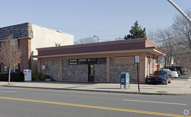
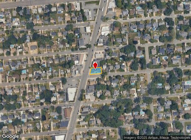
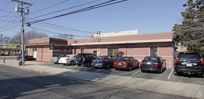
Property Record
684 Broadway, Massapequa, NY 11758
NEARBY LISTINGS FOR SALE OR LEASE
Property Detail
684 Broadway
2489-48-095-00-0051-0
TOWN #3 SCH DIST 023
Officebuilding
Nassau
X
New York
36103C0830H
51
2025
0.14 AC
2025
Southeast Nassau
521100
Long Island (New York)
5,008 SF
Nassau County-Suffolk County, NY
DEMOGRAPHICS near 684 Broadway
1 Mile
3 Mile
5 Mile
2024 Total Population
19,175
172,571
366,075
2029 Population
18,753
169,348
358,564
Pop Growth 2024-2029
(2.20%)
(1.87%)
(2.05%)
Average Age
42
42
42
2024 Total Households
6,426
57,595
120,992
HH Growth 2024-2029
(2.37%)
(2.01%)
(2.20%)
Median Household Inc
$129,154
$132,409
$129,737
Avg Household Size
2.90
2.90
2.90
2024 Avg HH Vehicles
2.00
2.00
2.00
Median Home Value
$635,773
$612,302
$589,872
Median Year Built
1955
1956
1956
Nearby Places
- Restaurants
- Banks
- Shops
- Fitness
- Groceries
PUBLIC TRANSPORTATION
COMMUTER RAIL
Massapequa Station (Babylon Branch - Long Island Rail Road)
DRIVE
WALK
Distance
Massapequa Station (Babylon Branch - Long Island Rail Road)
3 min
1.3 mi
Massapequa Park Station (Babylon Branch - Long Island Rail Road)
DRIVE
WALK
Distance
Massapequa Park Station (Babylon Branch - Long Island Rail Road)
4 min
1.6 mi
AIRPORT
John F Kennedy International
DRIVE
WALK
Distance
John F Kennedy International
30 min
20.4 mi
Long Island MacArthur
DRIVE
WALK
Distance
Long Island MacArthur
34 min
24.7 mi
LaGuardia
DRIVE
WALK
Distance
LaGuardia
41 min
27.4 mi
Freight Ports
NY - Red Hook Container Terminal
DRIVE
WALK
Distance
NY - Red Hook Container Terminal
51 min
31.8 mi
Nearby Properties
Address
Land Use
TOTAL SIZE
Lot Size
Zoning
Address
Land Use
TOTAL SIZE
Lot Size
Zoning
49,840 SF
729.60 AC
Address
Land Use
TOTAL SIZE
Lot Size
Zoning
9.95 AC
BUS3
Address
Land Use
TOTAL SIZE
Lot Size
Zoning
163.85 AC
Address
Land Use
TOTAL SIZE
Lot Size
Zoning
892,140 SF
31.82 AC
Address
Land Use
TOTAL SIZE
Lot Size
Zoning
105,868 SF
198 AC
Address
Land Use
TOTAL SIZE
Lot Size
Zoning
4,356 SF
246.70 AC
Address
Land Use
TOTAL SIZE
Lot Size
Zoning
Address
Land Use
TOTAL SIZE
Lot Size
Zoning
119,692 SF
24.59 AC
Address
Land Use
TOTAL SIZE
Lot Size
Zoning
3,900 SF
52.04 AC
Address
Land Use
TOTAL SIZE
Lot Size
Zoning
Address
Land Use
TOTAL SIZE
Lot Size
Zoning
22.10 AC
Address
Land Use
TOTAL SIZE
Lot Size
Zoning
17,305 SF
51.61 AC
Address
Land Use
TOTAL SIZE
Lot Size
Zoning
7.15 AC
Address
Land Use
TOTAL SIZE
Lot Size
Zoning
10,072 SF
22.75 AC
Address
Land Use
TOTAL SIZE
Lot Size
Zoning
1,500 SF
125.69 AC
Address
Land Use
TOTAL SIZE
Lot Size
Zoning
348,954 SF
9.98 AC
Address
Land Use
TOTAL SIZE
Lot Size
Zoning
8,000 SF
17.75 AC
Address
Land Use
TOTAL SIZE
Lot Size
Zoning
205,948 SF
15.21 AC
Address
Land Use
TOTAL SIZE
Lot Size
Zoning
120,000 SF
28.96 AC
Address
Land Use
TOTAL SIZE
Lot Size
Zoning
68,555 SF
20.14 AC
Address
Land Use
TOTAL SIZE
Lot Size
Zoning
3,700 SF
43.04 AC
Address
Land Use
TOTAL SIZE
Lot Size
Zoning
1,181 SF
25.01 AC
Address
Land Use
TOTAL SIZE
Lot Size
Zoning
76,790 SF
19.32 AC
Address
Land Use
TOTAL SIZE
Lot Size
Zoning
136,804 SF
10.56 AC
Address
Land Use
TOTAL SIZE
Lot Size
Zoning
112,053 SF
16.13 AC
Address
Land Use
TOTAL SIZE
Lot Size
Zoning
0.46 AC
R40
Address
Land Use
TOTAL SIZE
Lot Size
Zoning
13,200 SF
9.44 AC
Address
Land Use
TOTAL SIZE
Lot Size
Zoning
97,594 SF
13.53 AC
Address
Land Use
TOTAL SIZE
Lot Size
Zoning
28.33 AC
Address
Land Use
TOTAL SIZE
Lot Size
Zoning
79,735 SF
14.33 AC
The World's #1 Commercial Real Estate Marketplace
Connect with us
© 2025 CoStar Group
The information above has been obtained from sources believed reliable. While we do not doubt its accuracy we have not verified it and make no guarantee, warranty or representation about it. It is your responsibility to independently confirm its accuracy and completeness. Any projections, opinions, assumptions, or estimates used are for example only and do not represent the current or future performance of the property. The value of this transaction to you depends on tax and other factors which should be evaluated by your tax, financial, and legal advisors. You and your advisors should conduct a careful, independent investigation of the property to determine to your satisfaction the suitability of the property for your needs.